User: Password:   Login   Login with Facebook   Register

Send to a friend
   

Detailed analysis of the trail analyzed as Hiking (HKG)
Trail difficulty
121
HKG
Track : ord._an?isclo_desde_cierazils_saliendo_a_sercue_y_nerin_2023-10-07.gpx
These speeds are average for : RNG (Running)
Reanalyze as
BYC (Bicycle) RNG (Running)
 Reliability of the original trail: C   (833/50/1/16/-/70)
 Level of correction applied to the trail: 1        See original analysis (without corrections)
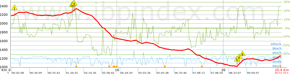
 Total length: 25.32 Km    mi / ft ?
 Analyzed distance: 25.32 Km
 Lineal distance: 6.45 Km
 Accumulated climb: 749.87 m  info Points list
 Accumulated descent: 1659.96 m
 Maximum height: 2342 m
 Minimal height: 1020.89 m
 Start height: 2179.6 m
 End height : 1269.4 m
 Climb rate: 9.46 %
 Descent rate: 10.3 %
 Positive climb difference per Km: 29.62 m
 Negative descent difference per Km: 65.56 m
 Max slope filter: ~55 %
 Min. points separation: ~30 m
 Number of points: 2182   (cad. 11.6 m)
 Significant points: 712   (cad. 35.81 m / 32.63 %)
 Direction changes per Km: 14.73
 Direction changes >5º per Km: 11.73
 Accumulated straight stretches: 2.765 Km
 Straight stretches per Km: 109.2 m
 Penalizables slope changes: 12
 Penalizables slope changes per Km: 0.474
 Total time: 9:57:33 h
 Time in movement: 7:48:42 h
 Stopped time: 2:08:51 h
 Total speed average: 2.54 Km/h
 Average speed in movement : 3.24 Km/h
 Maximum held speed: 9.6 Km/h


Altitude Slope % Speed Km/h Speed < 0.5 Km/h

Steep slopes > 5%

Steep slopes >5% Steep slopes >10% Steep slopes >15% Steep slopes >20% Steep slopes >25%
 Steep slope of 683 m.  Average slope  Interval  Download as waypoint
1
 km 0.077  6%  250 m
2
 km 0.327  15%  215 m
3
 km 0.542  14%  183 m
4
 km 0.725  8%  35 m
 Steep slope of 115 m.  Average slope  Interval  Download as waypoint
5
 km 1.306  7%  115 m
 Steep slope of 150 m.  Average slope  Interval  Download as waypoint
6
 km 3.009  5%  150 m
 Steep slope of 213 m.  Average slope  Interval  Download as waypoint
7
 km 3.941  5%  213 m
 Steep slope of 471 m.  Average slope  Interval  Download as waypoint
8
 km 4.669  11%  255 m
9
 km 4.924  9%  216 m
 Steep slope of 719 m.  Average slope  Interval  Download as waypoint
10
 km 5.416  7%  358 m
11
 km 5.774  14%  38 m
12
 km 5.812  25%  36 m
13
 km 5.849  25%  105 m
14
 km 5.954  25%  111 m
15
 km 6.065  6%  71 m
 Steep slope of 178 m.  Average slope  Interval  Download as waypoint
16
 km 11.31  9%  178 m
 Steep slope of 116 m.  Average slope  Interval  Download as waypoint
17
 km 11.629  11%  116 m
 Steep slope of 140 m.  Average slope  Interval  Download as waypoint
18
 km 12.373  12%  140 m
 Steep slope of 536 m.  Average slope  Interval  Download as waypoint
19
 km 16.085  6%  536 m
 Steep slope of 121 m.  Average slope  Interval  Download as waypoint
20
 km 19.565  6%  121 m
 Steep slope of 698 m.  Average slope  Interval  Download as waypoint
21
 km 21.254  24%  263 m
22
 km 21.517  26%  248 m
23
 km 21.765  22%  40 m
24
 km 21.805  15%  36 m
25
 km 21.841  15%  111 m
 Steep slope of 70 m.  Average slope  Interval  Download as waypoint
26
 km 22.063  11%  70 m
 Steep slope of 284 m.  Average slope  Interval  Download as waypoint
27
 km 23.654  8%  284 m
 Steep slope of 227 m.  Average slope  Interval  Download as waypoint
28
 km 24.738  10%  227 m


Compare this trail with...
Select trails to compare from "My trails". 
demo_montnegrebtt_2013.trk Ref.: 36172170671632
demo_matagalls_montserrat.trk Ref.: 36172170846048
demo_marathon_madrid_2013.trk Ref.: 36172170699197
Compare


Download (Registered users)

  GPX (.gpx)
  Garmin Training Center (.tcx)
  CompeGPS (.trk)
  OziExplorer (.plt)
  Google Earth (.kml)
  PDF analysis


Remove track and analysis
Save this trail on "My trails"


Send this analysis to a friend (Registered users)
Message that will receive your friend:
Re:
Hi.
(your name) has considered that this analysis of a trail could be of your interest.

(he/she will see a link to this page)
E-mail of your friend
You can enter multiple addresses separated by commas
Text
 
Send to a friend