User: Password:   Login   Login with Facebook   Register

Send to a friend
   

Detailed analysis of the trail analyzed as Bicycle (BYC)
Trail difficulty
845
BYC
Track : i727_2024_79cmx.gpx
These speeds are average for : RNG (Running)
Reanalyze as
HKG (Hiking) RNG (Running)
 Penalty trail's conditions: 75 %   ( > 50 % = MTB, < 50 % = RDB)
 Reliability of the original trail: C   (11646/53/0/-/-/53)
 Level of correction applied to the trail: 0
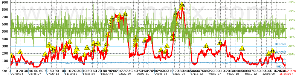
 Total length: 537.15 Km    mi / ft ?
 Analyzed distance: 537.15 Km
 Lineal distance: 0.01 Km
 Accumulated climb: 11611.83 m  info Points list
 Accumulated descent: 11604.05 m
 Maximum height: 839 m
 Minimal height: 16 m
 Start height: 33 m
 End height : 33 m
 Climb rate: 5.17 %
 Descent rate: 5.46 %
 Positive climb difference per Km: 21.62 m
 Negative descent difference per Km: 21.6 m
 Max slope filter: ~30 %
 Min. points separation: ~30 m
 Number of points: 14044   (cad. 38.25 m)
 Significant points: 9403   (cad. 57.13 m / 66.95 %)
 Direction changes per Km: 8.95
 Direction changes >5º per Km: 7.87
 Accumulated straight stretches: 39.936 Km
 Straight stretches per Km: 74.35 m
 Penalizables slope changes: 113
 Penalizables slope changes per Km: 0.21
 Total time: 56:56:06 h
 Time in movement: 56:56:06 h
 Stopped time: 0:00:00 h
 Total speed average: 9.43 Km/h
 Average speed in movement : 9.43 Km/h
 Maximum held speed: 10.19 Km/h
Your fitness level
?*
* fit = ? Not enought comparison elements or invalid track


Altitude Slope % Speed Km/h Speed < 2 Km/h

Steep slopes > 5%

Steep slopes >5% Steep slopes >10% Steep slopes >15% Steep slopes >20% Steep slopes >25%
 Steep slope of 344 m.  Average slope  Interval  Download as waypoint
1
 km 1.444  7%  152 m
2
 km 1.596  14%  192 m
 Steep slope of 131 m.  Average slope  Interval  Download as waypoint
3
 km 2.267  5%  131 m
 Steep slope of 380 m.  Average slope  Interval  Download as waypoint
4
 km 3.377  9%  380 m
 Steep slope of 705 m.  Average slope  Interval  Download as waypoint
5
 km 4.121  6%  705 m
 Steep slope of 161 m.  Average slope  Interval  Download as waypoint
6
 km 14.458  6%  161 m
 Steep slope of 109 m.  Average slope  Interval  Download as waypoint
7
 km 15.043  6%  109 m
 Steep slope of 278 m.  Average slope  Interval  Download as waypoint
8
 km 15.75  9%  278 m
 Steep slope of 480 m.  Average slope  Interval  Download as waypoint
9
 km 18.528  7%  248 m
10
 km 18.776  11%  109 m
11
 km 18.884  10%  123 m
 Steep slope of 241 m.  Average slope  Interval  Download as waypoint
12
 km 20.255  6%  241 m
 Steep slope of 113 m.  Average slope  Interval  Download as waypoint
13
 km 25.619  10%  113 m
 Steep slope of 126 m.  Average slope  Interval  Download as waypoint
14
 km 31.296  6%  126 m
 Steep slope of 209 m.  Average slope  Interval  Download as waypoint
15
 km 31.618  6%  209 m
 Steep slope of 303 m.  Average slope  Interval  Download as waypoint
16
 km 37.592  6%  303 m
 Steep slope of 335 m.  Average slope  Interval  Download as waypoint
17
 km 43.005  6%  335 m
 Steep slope of 346 m.  Average slope  Interval  Download as waypoint
18
 km 57.745  7%  346 m
 Steep slope of 133 m.  Average slope  Interval  Download as waypoint
19
 km 61.027  6%  133 m
 Steep slope of 198 m.  Average slope  Interval  Download as waypoint
20
 km 61.785  6%  198 m
 Steep slope of 532 m.  Average slope  Interval  Download as waypoint
21
 km 67.946  7%  42 m
22
 km 67.988  11%  110 m
23
 km 68.098  8%  380 m
 Steep slope of 269 m.  Average slope  Interval  Download as waypoint
24
 km 70.916  6%  269 m
 Steep slope of 728 m.  Average slope  Interval  Download as waypoint
25
 km 72.426  6%  455 m
26
 km 72.881  8%  168 m
27
 km 73.049  10%  105 m
 Steep slope of 316 m.  Average slope  Interval  Download as waypoint
28
 km 73.522  6%  316 m
 Steep slope of 241 m.  Average slope  Interval  Download as waypoint
29
 km 73.955  6%  241 m
 Steep slope of 121 m.  Average slope  Interval  Download as waypoint
30
 km 74.613  5%  121 m
 Steep slope of 137 m.  Average slope  Interval  Download as waypoint
31
 km 75.1  12%  137 m
 Steep slope of 257 m.  Average slope  Interval  Download as waypoint
32
 km 75.48  13%  172 m
33
 km 75.652  13%  85 m
 Steep slope of 222 m.  Average slope  Interval  Download as waypoint
34
 km 76.078  8%  222 m
 Steep slope of 301 m.  Average slope  Interval  Download as waypoint
35
 km 82.567  5%  301 m
 Steep slope of 171 m.  Average slope  Interval  Download as waypoint
36
 km 83.128  11%  129 m
37
 km 83.257  12%  42 m
 Steep slope of 313 m.  Average slope  Interval  Download as waypoint
38
 km 85.678  8%  197 m
39
 km 85.875  16%  116 m
 Steep slope of 650 m.  Average slope  Interval  Download as waypoint
40
 km 87.032  9%  34 m
41
 km 87.066  13%  131 m
42
 km 87.197  8%  485 m
 Steep slope of 527 m.  Average slope  Interval  Download as waypoint
43
 km 93.236  7%  527 m
 Steep slope of 530 m.  Average slope  Interval  Download as waypoint
44
 km 94.061  8%  530 m
 Steep slope of 716 m.  Average slope  Interval  Download as waypoint
45
 km 94.802  8%  716 m
 Steep slope of 212 m.  Average slope  Interval  Download as waypoint
46
 km 99.366  7%  212 m
 Steep slope of 612 m.  Average slope  Interval  Download as waypoint
47
 km 99.728  8%  612 m
 Steep slope of 189 m.  Average slope  Interval  Download as waypoint
48
 km 104.329  5%  189 m
 Steep slope of 420 m.  Average slope  Interval  Download as waypoint
49
 km 104.863  6%  205 m
50
 km 105.068  13%  215 m
 Steep slope of 121 m.  Average slope  Interval  Download as waypoint
51
 km 107.004  6%  121 m
 Steep slope of 318 m.  Average slope  Interval  Download as waypoint
52
 km 107.268  7%  195 m
53
 km 107.463  13%  123 m
 Steep slope of 573 m.  Average slope  Interval  Download as waypoint
54
 km 107.768  6%  34 m
55
 km 107.802  7%  121 m
56
 km 107.924  9%  418 m
 Steep slope of 204 m.  Average slope  Interval  Download as waypoint
57
 km 108.557  10%  204 m
 Steep slope of 368 m.  Average slope  Interval  Download as waypoint
58
 km 109.431  8%  368 m
 Steep slope of 159 m.  Average slope  Interval  Download as waypoint
59
 km 111.112  8%  159 m
 Steep slope of 386 m.  Average slope  Interval  Download as waypoint
60
 km 112.869  10%  386 m
 Steep slope of 394 m.  Average slope  Interval  Download as waypoint
61
 km 113.93  8%  394 m
 Steep slope of 483 m.  Average slope  Interval  Download as waypoint
62
 km 115.502  6%  97 m
63
 km 115.598  12%  292 m
64
 km 115.89  11%  94 m
 Steep slope of 158 m.  Average slope  Interval  Download as waypoint
65
 km 116.929  7%  158 m
 Steep slope of 194 m.  Average slope  Interval  Download as waypoint
66
 km 122.89  5%  194 m
 Steep slope of 173 m.  Average slope  Interval  Download as waypoint
67
 km 124.695  7%  173 m
 Steep slope of 248 m.  Average slope  Interval  Download as waypoint
68
 km 127.427  9%  33 m
69
 km 127.461  17%  119 m
70
 km 127.579  5%  96 m
 Steep slope of 115 m.  Average slope  Interval  Download as waypoint
71
 km 128.57  5%  115 m
 Steep slope of 207 m.  Average slope  Interval  Download as waypoint
72
 km 128.874  6%  207 m
 Steep slope of 489 m.  Average slope  Interval  Download as waypoint
73
 km 129.232  7%  192 m
74
 km 129.425  12%  175 m
75
 km 129.599  9%  122 m
 Steep slope of 162 m.  Average slope  Interval  Download as waypoint
76
 km 133.68  6%  162 m
 Steep slope of 178 m.  Average slope  Interval  Download as waypoint
77
 km 134.334  10%  178 m
 Steep slope of 248 m.  Average slope  Interval  Download as waypoint
78
 km 135.863  6%  248 m
 Steep slope of 285 m.  Average slope  Interval  Download as waypoint
79
 km 136.815  5%  285 m
 Steep slope of 240 m.  Average slope  Interval  Download as waypoint
80
 km 137.3  9%  240 m
 Steep slope of 628 m.  Average slope  Interval  Download as waypoint
81
 km 144.542  6%  107 m
82
 km 144.649  11%  271 m
83
 km 144.921  7%  250 m
 Steep slope of 232 m.  Average slope  Interval  Download as waypoint
84
 km 145.577  7%  232 m
 Steep slope of 124 m.  Average slope  Interval  Download as waypoint
85
 km 147.224  12%  124 m
 Steep slope of 311 m.  Average slope  Interval  Download as waypoint
86
 km 147.939  9%  311 m
 Steep slope of 114 m.  Average slope  Interval  Download as waypoint
87
 km 149.15  12%  114 m
 Steep slope of 305 m.  Average slope  Interval  Download as waypoint
88
 km 151.385  6%  305 m
 Steep slope of 784 m.  Average slope  Interval  Download as waypoint
89
 km 156.418  8%  784 m
 Steep slope of 453 m.  Average slope  Interval  Download as waypoint
90
 km 161.745  13%  390 m
91
 km 162.135  13%  63 m
 Steep slope of 253 m.  Average slope  Interval  Download as waypoint
92
 km 162.459  6%  47 m
93
 km 162.506  13%  128 m
94
 km 162.634  10%  78 m
 Steep slope of 329 m.  Average slope  Interval  Download as waypoint
95
 km 162.889  10%  145 m
96
 km 163.033  9%  184 m
 Steep slope of 190 m.  Average slope  Interval  Download as waypoint
97
 km 163.323  6%  190 m
 Steep slope of 226 m.  Average slope  Interval  Download as waypoint
98
 km 167.652  7%  226 m
 Steep slope of 446 m.  Average slope  Interval  Download as waypoint
99
 km 169.901  11%  413 m
100
 km 170.313  12%  33 m
 Steep slope of 148 m.  Average slope  Interval  Download as waypoint
101
 km 171.601  18%  148 m
 Steep slope of 271 m.  Average slope  Interval  Download as waypoint
102
 km 174.755  6%  271 m
 Steep slope of 348 m.  Average slope  Interval  Download as waypoint
103
 km 176.092  6%  348 m
 Steep slope of 202 m.  Average slope  Interval  Download as waypoint
104
 km 176.991  8%  202 m
 Steep slope of 242 m.  Average slope  Interval  Download as waypoint
105
 km 179.756  7%  242 m
 Steep slope of 381 m.  Average slope  Interval  Download as waypoint
106
 km 180.298  8%  381 m
 Steep slope of 200 m.  Average slope  Interval  Download as waypoint
107
 km 184.501  7%  200 m
 Steep slope of 512 m.  Average slope  Interval  Download as waypoint
108
 km 185.147  18%  141 m
109
 km 185.287  11%  100 m
110
 km 185.388  8%  271 m
 Steep slope of 317 m.  Average slope  Interval  Download as waypoint
111
 km 186.121  5%  317 m
 Steep slope of 595 m.  Average slope  Interval  Download as waypoint
112
 km 187.445  9%  538 m
113
 km 187.983  14%  57 m
 Steep slope of 2162 m.  Average slope  Interval  Download as waypoint
114
 km 188.293  8%  1203 m
115
 km 189.497  11%  130 m
116
 km 189.627  8%  829 m
 Steep slope of 314 m.  Average slope  Interval  Download as waypoint
117
 km 196.177  9%  177 m
118
 km 196.354  13%  89 m
119
 km 196.443  17%  48 m
 Steep slope of 367 m.  Average slope  Interval  Download as waypoint
120
 km 197.384  7%  367 m
 Steep slope of 1080 m.  Average slope  Interval  Download as waypoint
121
 km 197.902  15%  117 m
122
 km 198.019  6%  467 m
123
 km 198.486  11%  183 m
124
 km 198.669  9%  313 m
 Steep slope of 346 m.  Average slope  Interval  Download as waypoint
125
 km 199.851  9%  116 m
126
 km 199.967  9%  230 m
 Steep slope of 277 m.  Average slope  Interval  Download as waypoint
127
 km 200.409  5%  277 m
 Steep slope of 651 m.  Average slope  Interval  Download as waypoint
128
 km 201.048  7%  651 m
 Steep slope of 1366 m.  Average slope  Interval  Download as waypoint
129
 km 212.518  7%  122 m
130
 km 212.64  10%  136 m
131
 km 212.776  9%  259 m
132
 km 213.035  10%  191 m
133
 km 213.226  9%  148 m
134
 km 213.375  11%  196 m
135
 km 213.571  8%  314 m
 Steep slope of 297 m.  Average slope  Interval  Download as waypoint
136
 km 214.509  7%  297 m
 Steep slope of 133 m.  Average slope  Interval  Download as waypoint
137
 km 218.892  7%  133 m
 Steep slope of 213 m.  Average slope  Interval  Download as waypoint
138
 km 222.255  9%  213 m
 Steep slope of 679 m.  Average slope  Interval  Download as waypoint
139
 km 222.94  9%  400 m
140
 km 223.34  8%  279 m
 Steep slope of 457 m.  Average slope  Interval  Download as waypoint
141
 km 224.047  14%  230 m
142
 km 224.277  9%  227 m
 Steep slope of 294 m.  Average slope  Interval  Download as waypoint
143
 km 233.143  8%  294 m
 Steep slope of 135 m.  Average slope  Interval  Download as waypoint
144
 km 238.363  7%  135 m
 Steep slope of 216 m.  Average slope  Interval  Download as waypoint
145
 km 238.814  8%  216 m
 Steep slope of 251 m.  Average slope  Interval  Download as waypoint
146
 km 239.494  9%  251 m
 Steep slope of 1140 m.  Average slope  Interval  Download as waypoint
147
 km 243.646  5%  728 m
148
 km 244.373  11%  140 m
149
 km 244.514  15%  236 m
150
 km 244.75  17%  36 m
 Steep slope of 327 m.  Average slope  Interval  Download as waypoint
151
 km 244.937  9%  58 m
152
 km 244.995  11%  38 m
153
 km 245.033  16%  139 m
154
 km 245.172  14%  92 m
 Steep slope of 390 m.  Average slope  Interval  Download as waypoint
155
 km 247.749  8%  390 m
 Steep slope of 159 m.  Average slope  Interval  Download as waypoint
156
 km 261.712  5%  159 m
 Steep slope of 218 m.  Average slope  Interval  Download as waypoint
157
 km 262.017  6%  218 m
 Steep slope of 584 m.  Average slope  Interval  Download as waypoint
158
 km 262.39  7%  485 m
159
 km 262.875  12%  99 m
 Steep slope of 337 m.  Average slope  Interval  Download as waypoint
160
 km 264.657  5%  337 m
 Steep slope of 307 m.  Average slope  Interval  Download as waypoint
161
 km 265.513  9%  307 m
 Steep slope of 330 m.  Average slope  Interval  Download as waypoint
162
 km 267.12  9%  330 m
 Steep slope of 609 m.  Average slope  Interval  Download as waypoint
163
 km 268.913  8%  96 m
164
 km 269.008  11%  56 m
165
 km 269.064  9%  457 m
 Steep slope of 179 m.  Average slope  Interval  Download as waypoint
166
 km 269.72  6%  179 m
 Steep slope of 424 m.  Average slope  Interval  Download as waypoint
167
 km 275.612  8%  424 m
 Steep slope of 152 m.  Average slope  Interval  Download as waypoint
168
 km 279.074  14%  152 m
 Steep slope of 419 m.  Average slope  Interval  Download as waypoint
169
 km 289.078  8%  419 m
 Steep slope of 336 m.  Average slope  Interval  Download as waypoint
170
 km 293.269  6%  336 m
 Steep slope of 562 m.  Average slope  Interval  Download as waypoint
171
 km 293.742  5%  83 m
172
 km 293.825  10%  251 m
173
 km 294.076  13%  228 m
 Steep slope of 201 m.  Average slope  Interval  Download as waypoint
174
 km 297.814  5%  201 m
 Steep slope of 148 m.  Average slope  Interval  Download as waypoint
175
 km 302.522  8%  148 m
 Steep slope of 518 m.  Average slope  Interval  Download as waypoint
176
 km 303.224  6%  34 m
177
 km 303.258  12%  308 m
178
 km 303.566  7%  176 m
 Steep slope of 119 m.  Average slope  Interval  Download as waypoint
179
 km 305.102  8%  119 m
 Steep slope of 526 m.  Average slope  Interval  Download as waypoint
180
 km 305.338  13%  292 m
181
 km 305.63  8%  234 m
 Steep slope of 210 m.  Average slope  Interval  Download as waypoint
182
 km 307.505  7%  210 m
 Steep slope of 641 m.  Average slope  Interval  Download as waypoint
183
 km 314.276  6%  641 m
 Steep slope of 348 m.  Average slope  Interval  Download as waypoint
184
 km 315.099  6%  348 m
 Steep slope of 608 m.  Average slope  Interval  Download as waypoint
185
 km 316.704  8%  405 m
186
 km 317.109  12%  203 m
 Steep slope of 534 m.  Average slope  Interval  Download as waypoint
187
 km 317.466  10%  42 m
188
 km 317.508  14%  285 m
189
 km 317.793  9%  207 m
 Steep slope of 193 m.  Average slope  Interval  Download as waypoint
190
 km 318.134  11%  193 m
 Steep slope of 470 m.  Average slope  Interval  Download as waypoint
191
 km 318.462  5%  171 m
192
 km 318.633  15%  240 m
193
 km 318.873  7%  59 m
 Steep slope of 306 m.  Average slope  Interval  Download as waypoint
194
 km 319.097  7%  306 m
 Steep slope of 384 m.  Average slope  Interval  Download as waypoint
195
 km 319.537  8%  384 m
 Steep slope of 222 m.  Average slope  Interval  Download as waypoint
196
 km 320.21  5%  222 m
 Steep slope of 235 m.  Average slope  Interval  Download as waypoint
197
 km 322.003  13%  199 m
198
 km 322.202  11%  36 m
 Steep slope of 440 m.  Average slope  Interval  Download as waypoint
199
 km 322.363  11%  410 m
200
 km 322.773  13%  30 m
 Steep slope of 480 m.  Average slope  Interval  Download as waypoint
201
 km 322.961  12%  234 m
202
 km 323.195  9%  196 m
203
 km 323.391  18%  50 m
 Steep slope of 116 m.  Average slope  Interval  Download as waypoint
204
 km 325.538  6%  116 m
 Steep slope of 1233 m.  Average slope  Interval  Download as waypoint
205
 km 333.654  7%  441 m
206
 km 334.095  11%  412 m
207
 km 334.507  10%  380 m
 Steep slope of 227 m.  Average slope  Interval  Download as waypoint
208
 km 335.071  9%  101 m
209
 km 335.173  5%  126 m
 Steep slope of 428 m.  Average slope  Interval  Download as waypoint
210
 km 337.83  7%  428 m
 Steep slope of 424 m.  Average slope  Interval  Download as waypoint
211
 km 344.237  8%  424 m
 Steep slope of 179 m.  Average slope  Interval  Download as waypoint
212
 km 350.617  7%  179 m
 Steep slope of 218 m.  Average slope  Interval  Download as waypoint
213
 km 350.94  7%  218 m
 Steep slope of 896 m.  Average slope  Interval  Download as waypoint
214
 km 365.372  8%  896 m
 Steep slope of 169 m.  Average slope  Interval  Download as waypoint
215
 km 366.388  8%  169 m
 Steep slope of 179 m.  Average slope  Interval  Download as waypoint
216
 km 372.277  5%  179 m
 Steep slope of 257 m.  Average slope  Interval  Download as waypoint
217
 km 375.39  9%  257 m
 Steep slope of 373 m.  Average slope  Interval  Download as waypoint
218
 km 379.677  8%  373 m
 Steep slope of 249 m.  Average slope  Interval  Download as waypoint
219
 km 380.438  8%  249 m
 Steep slope of 589 m.  Average slope  Interval  Download as waypoint
220
 km 381.816  7%  404 m
221
 km 382.22  12%  185 m
 Steep slope of 205 m.  Average slope  Interval  Download as waypoint
222
 km 384.043  11%  205 m
 Steep slope of 105 m.  Average slope  Interval  Download as waypoint
223
 km 397.998  6%  105 m
 Steep slope of 203 m.  Average slope  Interval  Download as waypoint
224
 km 398.239  7%  203 m
 Steep slope of 125 m.  Average slope  Interval  Download as waypoint
225
 km 403.84  10%  125 m
 Steep slope of 143 m.  Average slope  Interval  Download as waypoint
226
 km 405.109  9%  143 m
 Steep slope of 195 m.  Average slope  Interval  Download as waypoint
227
 km 405.465  5%  195 m
 Steep slope of 179 m.  Average slope  Interval  Download as waypoint
228
 km 409.356  11%  179 m
 Steep slope of 285 m.  Average slope  Interval  Download as waypoint
229
 km 409.864  6%  285 m
 Steep slope of 206 m.  Average slope  Interval  Download as waypoint
230
 km 410.912  7%  206 m
 Steep slope of 398 m.  Average slope  Interval  Download as waypoint
231
 km 417.838  6%  398 m
 Steep slope of 236 m.  Average slope  Interval  Download as waypoint
232
 km 418.874  6%  236 m
 Steep slope of 342 m.  Average slope  Interval  Download as waypoint
233
 km 421.392  8%  342 m
 Steep slope of 268 m.  Average slope  Interval  Download as waypoint
234
 km 426.746  6%  268 m
 Steep slope of 257 m.  Average slope  Interval  Download as waypoint
235
 km 447.259  8%  257 m
 Steep slope of 122 m.  Average slope  Interval  Download as waypoint
236
 km 448.673  6%  122 m
 Steep slope of 335 m.  Average slope  Interval  Download as waypoint
237
 km 452.28  10%  239 m
238
 km 452.519  9%  96 m
 Steep slope of 132 m.  Average slope  Interval  Download as waypoint
239
 km 471.383  5%  132 m
 Steep slope of 117 m.  Average slope  Interval  Download as waypoint
240
 km 484.828  7%  117 m
 Steep slope of 302 m.  Average slope  Interval  Download as waypoint
241
 km 485.265  6%  302 m
 Steep slope of 182 m.  Average slope  Interval  Download as waypoint
242
 km 486.985  5%  182 m
 Steep slope of 170 m.  Average slope  Interval  Download as waypoint
243
 km 487.948  6%  170 m
 Steep slope of 170 m.  Average slope  Interval  Download as waypoint
244
 km 493.533  6%  170 m
 Steep slope of 294 m.  Average slope  Interval  Download as waypoint
245
 km 495.486  5%  294 m
 Steep slope of 311 m.  Average slope  Interval  Download as waypoint
246
 km 496.529  9%  311 m
 Steep slope of 140 m.  Average slope  Interval  Download as waypoint
247
 km 498.023  6%  140 m
 Steep slope of 279 m.  Average slope  Interval  Download as waypoint
248
 km 504.316  5%  60 m
249
 km 504.376  10%  123 m
250
 km 504.498  9%  96 m
 Steep slope of 266 m.  Average slope  Interval  Download as waypoint
251
 km 504.7  8%  266 m
 Steep slope of 107 m.  Average slope  Interval  Download as waypoint
252
 km 511.361  9%  107 m
 Steep slope of 1062 m.  Average slope  Interval  Download as waypoint
253
 km 511.698  6%  180 m
254
 km 511.878  11%  191 m
255
 km 512.069  5%  373 m
256
 km 512.442  5%  318 m
 Steep slope of 200 m.  Average slope  Interval  Download as waypoint
257
 km 513.878  8%  200 m
 Steep slope of 197 m.  Average slope  Interval  Download as waypoint
258
 km 515.818  6%  197 m
 Steep slope of 601 m.  Average slope  Interval  Download as waypoint
259
 km 517.846  7%  601 m
 Steep slope of 230 m.  Average slope  Interval  Download as waypoint
260
 km 520.019  7%  230 m
 Steep slope of 122 m.  Average slope  Interval  Download as waypoint
261
 km 520.801  10%  122 m
 Steep slope of 130 m.  Average slope  Interval  Download as waypoint
262
 km 521.658  6%  130 m
 Steep slope of 275 m.  Average slope  Interval  Download as waypoint
263
 km 524.043  10%  275 m
 Steep slope of 246 m.  Average slope  Interval  Download as waypoint
264
 km 525.634  7%  246 m
 Steep slope of 160 m.  Average slope  Interval  Download as waypoint
265
 km 530.183  8%  160 m


Compare this trail with...
Select trails to compare from "My trails". 
demo_montnegrebtt_2013.trk Ref.: 36172170671632
demo_matagalls_montserrat.trk Ref.: 36172170846048
demo_marathon_madrid_2013.trk Ref.: 36172170699197
Compare


Download (Registered users)

  GPX (.gpx)
  Garmin Training Center (.tcx)
  CompeGPS (.trk)
  OziExplorer (.plt)
  Google Earth (.kml)
  PDF analysis


Remove track and analysis
Save this trail on "My trails"


Send this analysis to a friend (Registered users)
Message that will receive your friend:
Re:
Hi.
(your name) has considered that this analysis of a trail could be of your interest.

(he/she will see a link to this page)
E-mail of your friend
You can enter multiple addresses separated by commas
Text
 
Send to a friend