Trail difficulty
239
RNG
|
| Track : MontnegreBTT 2013.gpx |
|
These speeds are average for : BYC
(Bicycle) Reanalyze as BYC (Bicycle) HKG (Hiking) |
|
|
| Level of correction applied to the trail: 0 |
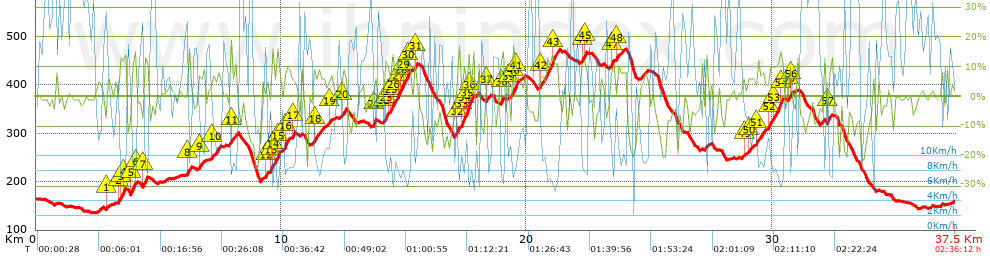
| Total length: 37.5 Km mi / ft ? |
| Analyzed distance: 37.5 Km |
| Lineal distance: 0 Km |
| Accumulated climb: 1160.8 m |
 info Points list info Points list |
| Accumulated descent: 1160 m | |
| Maximum height: 473.8 m | |
| Minimal height: 134.6 m | |
| Start height: 163 m | |
| End height : 159.6 m | |
| Climb rate: 6.95 % | |
| Descent rate: 7.21 % | |
| Positive climb difference per Km: 30.95 m | |
| Negative descent difference per Km: 30.93 m | |
| Max slope filter: ~55 % |
| Min. points separation: ~30 m |
| Number of points: 1975 (cad. 18.99 m) |
| Significant points: 902 (cad. 41.62 m / 45.67 %) |
| Direction changes per Km: 11.39 |
| Direction changes >5ş per Km: 10.05 |
| Accumulated straight stretches: 3.601 Km |
| Straight stretches per Km: 96.03 m |
| Penalizables slope changes: 14 |
| Penalizables slope changes per Km: 0.373 |
| Total time: 2:36:12 h |
| Time in movement: 2:36:12 h |
| Stopped time: 0:00:00 h |
| Total speed average: 14.4 Km/h |
| Average speed in movement : 14.4 Km/h |
| Maximum held speed: 39.59 Km/h |
 |
|
|
Remove track and analysis |
|
|
Save this trail on "My trails" |