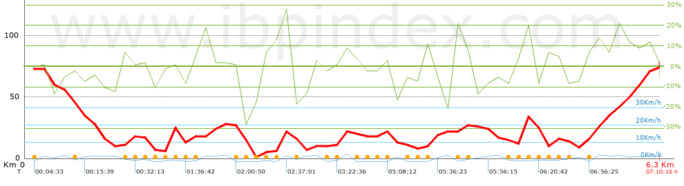
| Distancia total:
6.34 Km |
| Distancia analizada:
6.34 Km |
| Distancia lineal:
0 Km |
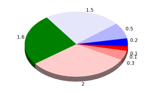
| Desn. de subida acumulado:
259.71 m |
| Desn. de bajada acumulado:
259.01
m |
| Altura máxima :
79.8 m |
| Altura mínima :
0 m |
| Ratio de subida:
8.91
% |
| Ratio de bajada :
9.59
% |
| Desnivel positivo por:
40.96 m |
| Desnivel negativo por:
40.85 m |
| Tiempo total :
7:10:16 h |
| Tiempo en movimiento:
1:24:43 h |
| Tiempo parado :
5:45:33 h |
|
|
| Filtro pendiente máxima:
~30 %
|
| Separación minima analizada:
~30 m |
| Número de puntos:
579 (cad. 10.95 m) |
| Puntos significativos :
177 (cad. 36.02 m / 30.57 %) |
| Puntos aberrantes:
48 (8.29 % d. total)
|
| Cambios dirección por:
11.83 |
| Cambios dirección > 5º por:
10.25 |
| Tramos rectos acumulados :
0.572
Km |
| Tramos rectos por :
90.22
m |
| Cambios de pendiente penalizables:
1 |
| Cambios de pendiente penalizables por:
0.158 |
| Velocidad media total:
0.88 Km/h |
| Velocidad media en movimiento:
4.49 Km/h |
| Velocidad máxima sostenida:
5.41
Km/h |
|