User: Password:   Login   Login with Facebook   Register

Send to a friend
   

Detailed analysis of the trail analyzed as Bicycle (BYC)
Trail difficulty
3091
BYC
Track : french-divide.gpx
These speeds are average for :  Drawn track (DRW)
Reanalyze as
HKG (Hiking) RNG (Running)
 Penalty trail's conditions: 37 %   ( > 50 % = MTB, < 50 % = RDB)
 Reliability of the original trail: DRW   (37013/62/0/-/-/62)
 Level of correction applied to the trail: 0
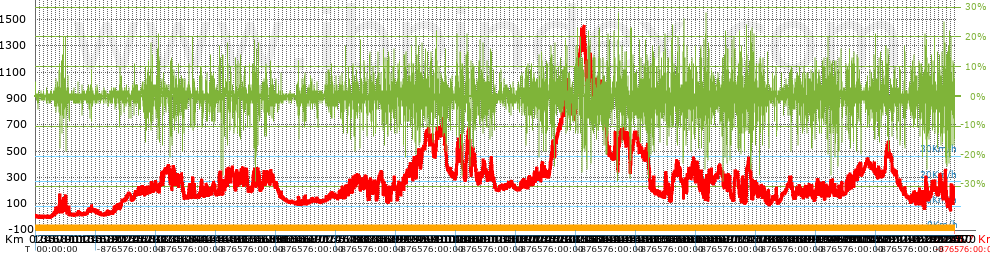
 Total length: 2270.69 Km    mi / ft ?
 Analyzed distance: 2270.69 Km
 Lineal distance: 908.58 Km
 Accumulated climb: 37022.63 m  info Points list
 Accumulated descent: 36857.63 m
 Maximum height: 1446.9 m
 Minimal height: -2.8 m
 Start height: 7.7 m
 End height : 171.8 m
 Climb rate: 4.68 %
 Descent rate: 4.67 %
 Positive climb difference per Km: 16.3 m
 Negative descent difference per Km: 16.23 m
 Max slope filter: ~30 %
 Min. points separation: ~30 m
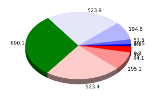
 Number of points: 22087   (cad. 102.81 m)
 Significant points: 18969   (cad. 119.71 m / 85.88 %)
 Direction changes per Km: 4.32
 Direction changes >5º per Km: 4.01
 Accumulated straight stretches: 74.453 Km
 Straight stretches per Km: 32.79 m
 Penalizables slope changes: 415
 Penalizables slope changes per Km: 0.183
 Total time: 0 h
 Time in movement: 0 h
 Stopped time: 0 h
 Total speed average: 0 Km/h
 Average speed in movement : 0 Km/h
 Maximum held speed: 0 Km/h
Your fitness level
?*
* fit = ? Not enought comparison elements or invalid track


Altitude Slope % Speed Km/h Speed < 2 Km/h

Steep slopes > 5%

Steep slopes >5% Steep slopes >10% Steep slopes >15% Steep slopes >20% Steep slopes >25%
 Steep slope of 1076 m.  Average slope  Interval  Download as waypoint
1
 km 59.25  7%  1076 m
 Steep slope of 208 m.  Average slope  Interval  Download as waypoint
2
 km 60.722  8%  208 m
 Steep slope of 940 m.  Average slope  Interval  Download as waypoint
3
 km 64.888  6%  940 m
 Steep slope of 329 m.  Average slope  Interval  Download as waypoint
4
 km 67.229  7%  87 m
5
 km 67.316  14%  164 m
6
 km 67.48  8%  78 m
 Steep slope of 320 m.  Average slope  Interval  Download as waypoint
7
 km 69.092  5%  320 m
 Steep slope of 301 m.  Average slope  Interval  Download as waypoint
8
 km 70.466  5%  301 m
 Steep slope of 585 m.  Average slope  Interval  Download as waypoint
9
 km 75.135  6%  248 m
10
 km 75.383  16%  337 m
 Steep slope of 184 m.  Average slope  Interval  Download as waypoint
11
 km 81.594  6%  184 m
 Steep slope of 319 m.  Average slope  Interval  Download as waypoint
12
 km 138.867  8%  319 m
 Steep slope of 423 m.  Average slope  Interval  Download as waypoint
13
 km 272.451  8%  423 m
 Steep slope of 239 m.  Average slope  Interval  Download as waypoint
14
 km 277.213  6%  239 m
 Steep slope of 456 m.  Average slope  Interval  Download as waypoint
15
 km 278.826  7%  456 m
 Steep slope of 186 m.  Average slope  Interval  Download as waypoint
16
 km 280.403  7%  186 m
 Steep slope of 209 m.  Average slope  Interval  Download as waypoint
17
 km 285.644  15%  209 m
 Steep slope of 288 m.  Average slope  Interval  Download as waypoint
18
 km 290.335  10%  288 m
 Steep slope of 598 m.  Average slope  Interval  Download as waypoint
19
 km 307.049  11%  396 m
20
 km 307.445  8%  202 m
 Steep slope of 848 m.  Average slope  Interval  Download as waypoint
21
 km 316.063  5%  848 m
 Steep slope of 542 m.  Average slope  Interval  Download as waypoint
22
 km 334.056  8%  542 m
 Steep slope of 371 m.  Average slope  Interval  Download as waypoint
23
 km 336.344  7%  240 m
24
 km 336.584  11%  131 m
 Steep slope of 921 m.  Average slope  Interval  Download as waypoint
25
 km 338.318  7%  921 m
 Steep slope of 228 m.  Average slope  Interval  Download as waypoint
26
 km 354.748  5%  228 m
 Steep slope of 1090 m.  Average slope  Interval  Download as waypoint
27
 km 388.225  11%  472 m
28
 km 388.698  16%  182 m
29
 km 388.88  14%  271 m
30
 km 389.151  14%  165 m
 Steep slope of 403 m.  Average slope  Interval  Download as waypoint
31
 km 392.184  5%  403 m
 Steep slope of 539 m.  Average slope  Interval  Download as waypoint
32
 km 408.144  9%  539 m
 Steep slope of 318 m.  Average slope  Interval  Download as waypoint
33
 km 410.092  8%  318 m
 Steep slope of 388 m.  Average slope  Interval  Download as waypoint
34
 km 424.088  6%  388 m
 Steep slope of 356 m.  Average slope  Interval  Download as waypoint
35
 km 432.913  8%  356 m
 Steep slope of 489 m.  Average slope  Interval  Download as waypoint
36
 km 436.242  6%  489 m
 Steep slope of 1264 m.  Average slope  Interval  Download as waypoint
37
 km 453.746  10%  1264 m
 Steep slope of 356 m.  Average slope  Interval  Download as waypoint
38
 km 462.744  10%  356 m
 Steep slope of 1472 m.  Average slope  Interval  Download as waypoint
39
 km 464.03  11%  358 m
40
 km 464.388  5%  1114 m
 Steep slope of 633 m.  Average slope  Interval  Download as waypoint
41
 km 474.938  6%  415 m
42
 km 475.353  15%  187 m
43
 km 475.54  6%  31 m
 Steep slope of 208 m.  Average slope  Interval  Download as waypoint
44
 km 475.706  9%  208 m
 Steep slope of 572 m.  Average slope  Interval  Download as waypoint
45
 km 476.121  6%  572 m
 Steep slope of 1279 m.  Average slope  Interval  Download as waypoint
46
 km 495.181  8%  1279 m
 Steep slope of 297 m.  Average slope  Interval  Download as waypoint
47
 km 500.404  7%  297 m
 Steep slope of 596 m.  Average slope  Interval  Download as waypoint
48
 km 505.509  6%  596 m
 Steep slope of 569 m.  Average slope  Interval  Download as waypoint
49
 km 507.031  7%  569 m
 Steep slope of 210 m.  Average slope  Interval  Download as waypoint
50
 km 516.058  5%  210 m
 Steep slope of 136 m.  Average slope  Interval  Download as waypoint
51
 km 516.942  6%  136 m
 Steep slope of 906 m.  Average slope  Interval  Download as waypoint
52
 km 517.238  7%  906 m
 Steep slope of 260 m.  Average slope  Interval  Download as waypoint
53
 km 529.071  5%  173 m
54
 km 529.244  5%  87 m
 Steep slope of 846 m.  Average slope  Interval  Download as waypoint
55
 km 537.167  8%  846 m
 Steep slope of 791 m.  Average slope  Interval  Download as waypoint
56
 km 538.328  8%  791 m
 Steep slope of 555 m.  Average slope  Interval  Download as waypoint
57
 km 541.083  5%  353 m
58
 km 541.436  14%  202 m
 Steep slope of 530 m.  Average slope  Interval  Download as waypoint
59
 km 546.44  7%  530 m
 Steep slope of 443 m.  Average slope  Interval  Download as waypoint
60
 km 547.419  7%  443 m
 Steep slope of 456 m.  Average slope  Interval  Download as waypoint
61
 km 551.608  14%  456 m
 Steep slope of 534 m.  Average slope  Interval  Download as waypoint
62
 km 564.481  5%  534 m
 Steep slope of 938 m.  Average slope  Interval  Download as waypoint
63
 km 568.543  8%  938 m
 Steep slope of 899 m.  Average slope  Interval  Download as waypoint
64
 km 571.324  6%  899 m
 Steep slope of 796 m.  Average slope  Interval  Download as waypoint
65
 km 581.102  9%  796 m
 Steep slope of 367 m.  Average slope  Interval  Download as waypoint
66
 km 606.714  7%  367 m
 Steep slope of 417 m.  Average slope  Interval  Download as waypoint
67
 km 649.768  8%  417 m
 Steep slope of 332 m.  Average slope  Interval  Download as waypoint
68
 km 757.222  5%  332 m
 Steep slope of 571 m.  Average slope  Interval  Download as waypoint
69
 km 765.968  9%  571 m
 Steep slope of 210 m.  Average slope  Interval  Download as waypoint
70
 km 773.324  7%  210 m
 Steep slope of 168 m.  Average slope  Interval  Download as waypoint
71
 km 773.889  5%  168 m
 Steep slope of 940 m.  Average slope  Interval  Download as waypoint
72
 km 783.721  8%  940 m
 Steep slope of 157 m.  Average slope  Interval  Download as waypoint
73
 km 784.995  6%  157 m
 Steep slope of 421 m.  Average slope  Interval  Download as waypoint
74
 km 803.208  10%  421 m
 Steep slope of 223 m.  Average slope  Interval  Download as waypoint
75
 km 813.497  7%  223 m
 Steep slope of 503 m.  Average slope  Interval  Download as waypoint
76
 km 824.872  7%  447 m
77
 km 825.319  14%  56 m
 Steep slope of 436 m.  Average slope  Interval  Download as waypoint
78
 km 826.022  12%  332 m
79
 km 826.354  15%  104 m
 Steep slope of 463 m.  Average slope  Interval  Download as waypoint
80
 km 833.902  8%  463 m
 Steep slope of 610 m.  Average slope  Interval  Download as waypoint
81
 km 835.891  7%  610 m
 Steep slope of 772 m.  Average slope  Interval  Download as waypoint
82
 km 845.667  6%  409 m
83
 km 846.076  14%  363 m
 Steep slope of 796 m.  Average slope  Interval  Download as waypoint
84
 km 860.12  8%  48 m
85
 km 860.168  13%  486 m
86
 km 860.654  9%  262 m
 Steep slope of 685 m.  Average slope  Interval  Download as waypoint
87
 km 863.286  9%  685 m
 Steep slope of 711 m.  Average slope  Interval  Download as waypoint
88
 km 868.941  9%  283 m
89
 km 869.223  12%  284 m
90
 km 869.507  7%  144 m
 Steep slope of 972 m.  Average slope  Interval  Download as waypoint
91
 km 872.662  7%  247 m
92
 km 872.909  12%  369 m
93
 km 873.278  8%  356 m
 Steep slope of 342 m.  Average slope  Interval  Download as waypoint
94
 km 883.886  9%  342 m
 Steep slope of 701 m.  Average slope  Interval  Download as waypoint
95
 km 885.601  9%  90 m
96
 km 885.691  12%  421 m
97
 km 886.112  6%  190 m
 Steep slope of 168 m.  Average slope  Interval  Download as waypoint
98
 km 887.598  6%  168 m
 Steep slope of 649 m.  Average slope  Interval  Download as waypoint
99
 km 895.416  9%  649 m
 Steep slope of 411 m.  Average slope  Interval  Download as waypoint
100
 km 899.204  9%  411 m
 Steep slope of 532 m.  Average slope  Interval  Download as waypoint
101
 km 910.931  8%  165 m
102
 km 911.097  15%  100 m
103
 km 911.197  7%  267 m
 Steep slope of 355 m.  Average slope  Interval  Download as waypoint
104
 km 911.58  9%  79 m
105
 km 911.658  14%  230 m
106
 km 911.889  6%  46 m
 Steep slope of 166 m.  Average slope  Interval  Download as waypoint
107
 km 912.389  7%  166 m
 Steep slope of 231 m.  Average slope  Interval  Download as waypoint
108
 km 916.152  8%  231 m
 Steep slope of 197 m.  Average slope  Interval  Download as waypoint
109
 km 916.686  8%  197 m
 Steep slope of 230 m.  Average slope  Interval  Download as waypoint
110
 km 920.255  6%  230 m
 Steep slope of 362 m.  Average slope  Interval  Download as waypoint
111
 km 923.197  7%  362 m
 Steep slope of 387 m.  Average slope  Interval  Download as waypoint
112
 km 928.603  8%  53 m
113
 km 928.656  12%  241 m
114
 km 928.897  10%  93 m
 Steep slope of 185 m.  Average slope  Interval  Download as waypoint
115
 km 929.282  6%  185 m
 Steep slope of 216 m.  Average slope  Interval  Download as waypoint
116
 km 929.869  6%  216 m
 Steep slope of 472 m.  Average slope  Interval  Download as waypoint
117
 km 932.853  8%  472 m
 Steep slope of 303 m.  Average slope  Interval  Download as waypoint
118
 km 933.552  7%  303 m
 Steep slope of 628 m.  Average slope  Interval  Download as waypoint
119
 km 933.985  8%  29 m
120
 km 934.014  12%  113 m
121
 km 934.127  5%  486 m
 Steep slope of 118 m.  Average slope  Interval  Download as waypoint
122
 km 934.816  7%  118 m
 Steep slope of 867 m.  Average slope  Interval  Download as waypoint
123
 km 941.122  8%  201 m
124
 km 941.323  13%  304 m
125
 km 941.627  7%  362 m
 Steep slope of 165 m.  Average slope  Interval  Download as waypoint
126
 km 942.153  9%  165 m
 Steep slope of 260 m.  Average slope  Interval  Download as waypoint
127
 km 943.921  8%  260 m
 Steep slope of 272 m.  Average slope  Interval  Download as waypoint
128
 km 945.468  12%  272 m
 Steep slope of 575 m.  Average slope  Interval  Download as waypoint
129
 km 945.879  7%  575 m
 Steep slope of 183 m.  Average slope  Interval  Download as waypoint
130
 km 949.463  9%  183 m
 Steep slope of 190 m.  Average slope  Interval  Download as waypoint
131
 km 952.171  7%  190 m
 Steep slope of 229 m.  Average slope  Interval  Download as waypoint
132
 km 954.407  7%  229 m
 Steep slope of 378 m.  Average slope  Interval  Download as waypoint
133
 km 955.304  6%  201 m
134
 km 955.505  14%  177 m
 Steep slope of 468 m.  Average slope  Interval  Download as waypoint
135
 km 962.906  7%  468 m
 Steep slope of 428 m.  Average slope  Interval  Download as waypoint
136
 km 963.823  8%  270 m
137
 km 964.092  15%  158 m
 Steep slope of 376 m.  Average slope  Interval  Download as waypoint
138
 km 968.254  10%  376 m
 Steep slope of 444 m.  Average slope  Interval  Download as waypoint
139
 km 978.41  6%  444 m
 Steep slope of 500 m.  Average slope  Interval  Download as waypoint
140
 km 988.521  8%  500 m
 Steep slope of 863 m.  Average slope  Interval  Download as waypoint
141
 km 989.909  8%  863 m
 Steep slope of 308 m.  Average slope  Interval  Download as waypoint
142
 km 991.35  6%  308 m
 Steep slope of 277 m.  Average slope  Interval  Download as waypoint
143
 km 996.937  5%  277 m
 Steep slope of 311 m.  Average slope  Interval  Download as waypoint
144
 km 1001.671  5%  311 m
 Steep slope of 355 m.  Average slope  Interval  Download as waypoint
145
 km 1003.331  6%  355 m
 Steep slope of 395 m.  Average slope  Interval  Download as waypoint
146
 km 1039.225  5%  395 m
 Steep slope of 1913 m.  Average slope  Interval  Download as waypoint
147
 km 1040.205  8%  262 m
148
 km 1040.467  11%  468 m
149
 km 1040.935  7%  452 m
150
 km 1041.387  14%  198 m
151
 km 1041.585  7%  339 m
152
 km 1041.923  8%  194 m
 Steep slope of 136 m.  Average slope  Interval  Download as waypoint
153
 km 1042.256  7%  136 m
 Steep slope of 613 m.  Average slope  Interval  Download as waypoint
154
 km 1042.824  6%  613 m
 Steep slope of 229 m.  Average slope  Interval  Download as waypoint
155
 km 1048.668  5%  229 m
 Steep slope of 517 m.  Average slope  Interval  Download as waypoint
156
 km 1049.063  9%  186 m
157
 km 1049.249  5%  170 m
158
 km 1049.419  10%  161 m
 Steep slope of 201 m.  Average slope  Interval  Download as waypoint
159
 km 1049.856  7%  201 m
 Steep slope of 673 m.  Average slope  Interval  Download as waypoint
160
 km 1050.404  13%  275 m
161
 km 1050.678  7%  398 m
 Steep slope of 176 m.  Average slope  Interval  Download as waypoint
162
 km 1051.325  8%  176 m
 Steep slope of 309 m.  Average slope  Interval  Download as waypoint
163
 km 1055.568  9%  309 m
 Steep slope of 124 m.  Average slope  Interval  Download as waypoint
164
 km 1057.344  7%  124 m
 Steep slope of 3219 m.  Average slope  Interval  Download as waypoint
165
 km 1062.94  7%  879 m
166
 km 1063.819  9%  206 m
167
 km 1064.025  6%  850 m
168
 km 1064.875  7%  592 m
169
 km 1065.467  14%  310 m
170
 km 1065.777  8%  382 m
 Steep slope of 497 m.  Average slope  Interval  Download as waypoint
171
 km 1070.328  6%  497 m
 Steep slope of 748 m.  Average slope  Interval  Download as waypoint
172
 km 1076.309  6%  748 m
 Steep slope of 289 m.  Average slope  Interval  Download as waypoint
173
 km 1079.337  7%  289 m
 Steep slope of 546 m.  Average slope  Interval  Download as waypoint
174
 km 1080.222  8%  546 m
 Steep slope of 119 m.  Average slope  Interval  Download as waypoint
175
 km 1083.931  8%  119 m
 Steep slope of 627 m.  Average slope  Interval  Download as waypoint
176
 km 1094.752  7%  627 m
 Steep slope of 405 m.  Average slope  Interval  Download as waypoint
177
 km 1095.983  9%  405 m
 Steep slope of 361 m.  Average slope  Interval  Download as waypoint
178
 km 1097.606  10%  361 m
 Steep slope of 270 m.  Average slope  Interval  Download as waypoint
179
 km 1098.818  6%  270 m
 Steep slope of 239 m.  Average slope  Interval  Download as waypoint
180
 km 1102.384  8%  239 m
 Steep slope of 326 m.  Average slope  Interval  Download as waypoint
181
 km 1103.668  5%  326 m
 Steep slope of 283 m.  Average slope  Interval  Download as waypoint
182
 km 1105.089  5%  283 m
 Steep slope of 266 m.  Average slope  Interval  Download as waypoint
183
 km 1105.609  5%  38 m
184
 km 1105.647  14%  153 m
185
 km 1105.801  10%  75 m
 Steep slope of 519 m.  Average slope  Interval  Download as waypoint
186
 km 1123.24  6%  196 m
187
 km 1123.435  11%  323 m
 Steep slope of 888 m.  Average slope  Interval  Download as waypoint
188
 km 1124.254  8%  888 m
 Steep slope of 366 m.  Average slope  Interval  Download as waypoint
189
 km 1125.858  11%  366 m
 Steep slope of 414 m.  Average slope  Interval  Download as waypoint
190
 km 1216.843  6%  414 m
 Steep slope of 252 m.  Average slope  Interval  Download as waypoint
191
 km 1223.184  8%  252 m
 Steep slope of 479 m.  Average slope  Interval  Download as waypoint
192
 km 1224.677  7%  479 m
 Steep slope of 455 m.  Average slope  Interval  Download as waypoint
193
 km 1231.833  7%  455 m
 Steep slope of 171 m.  Average slope  Interval  Download as waypoint
194
 km 1243.694  6%  171 m
 Steep slope of 186 m.  Average slope  Interval  Download as waypoint
195
 km 1250.336  15%  186 m
 Steep slope of 612 m.  Average slope  Interval  Download as waypoint
196
 km 1251.379  6%  155 m
197
 km 1251.534  12%  143 m
198
 km 1251.677  7%  314 m
 Steep slope of 800 m.  Average slope  Interval  Download as waypoint
199
 km 1255.67  5%  800 m
 Steep slope of 188 m.  Average slope  Interval  Download as waypoint
200
 km 1263.107  10%  188 m
 Steep slope of 327 m.  Average slope  Interval  Download as waypoint
201
 km 1263.992  6%  327 m
 Steep slope of 572 m.  Average slope  Interval  Download as waypoint
202
 km 1271.551  8%  572 m
 Steep slope of 582 m.  Average slope  Interval  Download as waypoint
203
 km 1272.978  8%  582 m
 Steep slope of 423 m.  Average slope  Interval  Download as waypoint
204
 km 1276.193  6%  81 m
205
 km 1276.274  13%  342 m
 Steep slope of 313 m.  Average slope  Interval  Download as waypoint
206
 km 1277.469  8%  313 m
 Steep slope of 842 m.  Average slope  Interval  Download as waypoint
207
 km 1282.755  6%  436 m
208
 km 1283.191  14%  406 m
 Steep slope of 208 m.  Average slope  Interval  Download as waypoint
209
 km 1286.891  8%  208 m
 Steep slope of 413 m.  Average slope  Interval  Download as waypoint
210
 km 1294.558  6%  413 m
 Steep slope of 846 m.  Average slope  Interval  Download as waypoint
211
 km 1296.614  7%  846 m
 Steep slope of 259 m.  Average slope  Interval  Download as waypoint
212
 km 1300.392  8%  259 m
 Steep slope of 251 m.  Average slope  Interval  Download as waypoint
213
 km 1300.825  5%  251 m
 Steep slope of 208 m.  Average slope  Interval  Download as waypoint
214
 km 1305.617  7%  208 m
 Steep slope of 220 m.  Average slope  Interval  Download as waypoint
215
 km 1306.088  8%  220 m
 Steep slope of 231 m.  Average slope  Interval  Download as waypoint
216
 km 1307.199  7%  231 m
 Steep slope of 150 m.  Average slope  Interval  Download as waypoint
217
 km 1308.415  8%  150 m
 Steep slope of 983 m.  Average slope  Interval  Download as waypoint
218
 km 1308.969  11%  983 m
 Steep slope of 545 m.  Average slope  Interval  Download as waypoint
219
 km 1312.097  7%  545 m
 Steep slope of 257 m.  Average slope  Interval  Download as waypoint
220
 km 1319.318  6%  257 m
 Steep slope of 354 m.  Average slope  Interval  Download as waypoint
221
 km 1331.341  6%  354 m
 Steep slope of 568 m.  Average slope  Interval  Download as waypoint
222
 km 1334.287  7%  364 m
223
 km 1334.651  9%  204 m
 Steep slope of 761 m.  Average slope  Interval  Download as waypoint
224
 km 1335.323  7%  761 m
 Steep slope of 1002 m.  Average slope  Interval  Download as waypoint
225
 km 1337.868  6%  333 m
226
 km 1338.201  13%  386 m
227
 km 1338.587  8%  130 m
228
 km 1338.716  15%  153 m
 Steep slope of 1005 m.  Average slope  Interval  Download as waypoint
229
 km 1341.324  7%  1005 m
 Steep slope of 606 m.  Average slope  Interval  Download as waypoint
230
 km 1342.618  7%  606 m
 Steep slope of 339 m.  Average slope  Interval  Download as waypoint
231
 km 1343.575  6%  339 m
 Steep slope of 443 m.  Average slope  Interval  Download as waypoint
232
 km 1346.015  7%  331 m
233
 km 1346.346  5%  112 m
 Steep slope of 860 m.  Average slope  Interval  Download as waypoint
234
 km 1347.444  9%  288 m
235
 km 1347.732  8%  572 m
 Steep slope of 624 m.  Average slope  Interval  Download as waypoint
236
 km 1348.786  9%  624 m
 Steep slope of 983 m.  Average slope  Interval  Download as waypoint
237
 km 1351.205  7%  343 m
238
 km 1351.549  12%  160 m
239
 km 1351.709  6%  480 m
 Steep slope of 980 m.  Average slope  Interval  Download as waypoint
240
 km 1364.262  7%  292 m
241
 km 1364.554  18%  161 m
242
 km 1364.715  8%  176 m
243
 km 1364.891  10%  351 m
 Steep slope of 199 m.  Average slope  Interval  Download as waypoint
244
 km 1365.788  12%  199 m
 Steep slope of 1486 m.  Average slope  Interval  Download as waypoint
245
 km 1366.112  11%  135 m
246
 km 1366.246  10%  242 m
247
 km 1366.489  11%  153 m
248
 km 1366.642  7%  98 m
249
 km 1366.74  12%  73 m
250
 km 1366.813  12%  247 m
251
 km 1367.061  8%  538 m
 Steep slope of 204 m.  Average slope  Interval  Download as waypoint
252
 km 1367.836  6%  204 m
 Steep slope of 114 m.  Average slope  Interval  Download as waypoint
253
 km 1368.234  7%  114 m
 Steep slope of 347 m.  Average slope  Interval  Download as waypoint
254
 km 1369.615  8%  261 m
255
 km 1369.876  14%  86 m
 Steep slope of 549 m.  Average slope  Interval  Download as waypoint
256
 km 1376.882  6%  549 m
 Steep slope of 140 m.  Average slope  Interval  Download as waypoint
257
 km 1379.122  12%  140 m
 Steep slope of 435 m.  Average slope  Interval  Download as waypoint
258
 km 1379.534  7%  435 m
 Steep slope of 199 m.  Average slope  Interval  Download as waypoint
259
 km 1381.174  5%  199 m
 Steep slope of 509 m.  Average slope  Interval  Download as waypoint
260
 km 1381.796  7%  509 m
 Steep slope of 185 m.  Average slope  Interval  Download as waypoint
261
 km 1387.177  7%  185 m
 Steep slope of 320 m.  Average slope  Interval  Download as waypoint
262
 km 1388.832  6%  320 m
 Steep slope of 107 m.  Average slope  Interval  Download as waypoint
263
 km 1389.284  7%  107 m
 Steep slope of 318 m.  Average slope  Interval  Download as waypoint
264
 km 1390.992  7%  318 m
 Steep slope of 124 m.  Average slope  Interval  Download as waypoint
265
 km 1391.519  8%  124 m
 Steep slope of 139 m.  Average slope  Interval  Download as waypoint
266
 km 1391.775  11%  139 m
 Steep slope of 190 m.  Average slope  Interval  Download as waypoint
267
 km 1393.633  6%  46 m
268
 km 1393.679  18%  144 m
 Steep slope of 245 m.  Average slope  Interval  Download as waypoint
269
 km 1402.24  11%  245 m
 Steep slope of 303 m.  Average slope  Interval  Download as waypoint
270
 km 1417.065  9%  303 m
 Steep slope of 259 m.  Average slope  Interval  Download as waypoint
271
 km 1429.078  10%  259 m
 Steep slope of 1458 m.  Average slope  Interval  Download as waypoint
272
 km 1430.49  7%  607 m
273
 km 1431.097  12%  216 m
274
 km 1431.313  8%  207 m
275
 km 1431.52  11%  428 m
 Steep slope of 572 m.  Average slope  Interval  Download as waypoint
276
 km 1438.621  8%  366 m
277
 km 1438.986  11%  206 m
 Steep slope of 895 m.  Average slope  Interval  Download as waypoint
278
 km 1439.858  9%  459 m
279
 km 1440.317  14%  436 m
 Steep slope of 487 m.  Average slope  Interval  Download as waypoint
280
 km 1443.404  8%  487 m
 Steep slope of 297 m.  Average slope  Interval  Download as waypoint
281
 km 1452.579  8%  297 m
 Steep slope of 374 m.  Average slope  Interval  Download as waypoint
282
 km 1455.822  11%  374 m
 Steep slope of 592 m.  Average slope  Interval  Download as waypoint
283
 km 1459.622  8%  592 m
 Steep slope of 282 m.  Average slope  Interval  Download as waypoint
284
 km 1469.475  10%  282 m
 Steep slope of 789 m.  Average slope  Interval  Download as waypoint
285
 km 1470.029  7%  590 m
286
 km 1470.62  21%  199 m
 Steep slope of 705 m.  Average slope  Interval  Download as waypoint
287
 km 1470.863  5%  353 m
288
 km 1471.216  13%  352 m
 Steep slope of 169 m.  Average slope  Interval  Download as waypoint
289
 km 1475.685  10%  169 m
 Steep slope of 431 m.  Average slope  Interval  Download as waypoint
290
 km 1477.421  5%  431 m
 Steep slope of 490 m.  Average slope  Interval  Download as waypoint
291
 km 1484.568  6%  490 m
 Steep slope of 341 m.  Average slope  Interval  Download as waypoint
292
 km 1492.061  6%  191 m
293
 km 1492.251  15%  150 m
 Steep slope of 155 m.  Average slope  Interval  Download as waypoint
294
 km 1494.963  9%  155 m
 Steep slope of 354 m.  Average slope  Interval  Download as waypoint
295
 km 1499.808  6%  354 m
 Steep slope of 280 m.  Average slope  Interval  Download as waypoint
296
 km 1503.569  9%  280 m
 Steep slope of 542 m.  Average slope  Interval  Download as waypoint
297
 km 1504.451  5%  542 m
 Steep slope of 411 m.  Average slope  Interval  Download as waypoint
298
 km 1506.441  6%  177 m
299
 km 1506.618  15%  234 m
 Steep slope of 346 m.  Average slope  Interval  Download as waypoint
300
 km 1508.608  6%  346 m
 Steep slope of 269 m.  Average slope  Interval  Download as waypoint
301
 km 1510.406  8%  269 m
 Steep slope of 434 m.  Average slope  Interval  Download as waypoint
302
 km 1511.014  5%  434 m
 Steep slope of 433 m.  Average slope  Interval  Download as waypoint
303
 km 1514.966  5%  433 m
 Steep slope of 383 m.  Average slope  Interval  Download as waypoint
304
 km 1518.664  7%  383 m
 Steep slope of 810 m.  Average slope  Interval  Download as waypoint
305
 km 1525.711  14%  217 m
306
 km 1525.927  10%  593 m
 Steep slope of 350 m.  Average slope  Interval  Download as waypoint
307
 km 1541.688  9%  350 m
 Steep slope of 264 m.  Average slope  Interval  Download as waypoint
308
 km 1550.714  11%  264 m
 Steep slope of 1495 m.  Average slope  Interval  Download as waypoint
309
 km 1554.833  6%  190 m
310
 km 1555.023  16%  254 m
311
 km 1555.277  14%  254 m
312
 km 1555.531  5%  121 m
313
 km 1555.652  9%  676 m
 Steep slope of 390 m.  Average slope  Interval  Download as waypoint
314
 km 1561.675  7%  30 m
315
 km 1561.705  11%  360 m
 Steep slope of 268 m.  Average slope  Interval  Download as waypoint
316
 km 1562.725  10%  268 m
 Steep slope of 202 m.  Average slope  Interval  Download as waypoint
317
 km 1569.552  6%  202 m
 Steep slope of 224 m.  Average slope  Interval  Download as waypoint
318
 km 1571.676  7%  224 m
 Steep slope of 250 m.  Average slope  Interval  Download as waypoint
319
 km 1572.939  7%  250 m
 Steep slope of 985 m.  Average slope  Interval  Download as waypoint
320
 km 1573.458  20%  47 m
321
 km 1573.505  9%  938 m
 Steep slope of 235 m.  Average slope  Interval  Download as waypoint
322
 km 1580.275  6%  235 m
 Steep slope of 992 m.  Average slope  Interval  Download as waypoint
323
 km 1582.039  7%  992 m
 Steep slope of 856 m.  Average slope  Interval  Download as waypoint
324
 km 1586.111  10%  856 m
 Steep slope of 426 m.  Average slope  Interval  Download as waypoint
325
 km 1589.926  6%  80 m
326
 km 1590.006  12%  346 m
 Steep slope of 841 m.  Average slope  Interval  Download as waypoint
327
 km 1600.78  7%  634 m
328
 km 1601.414  26%  131 m
329
 km 1601.546  27%  76 m
 Steep slope of 616 m.  Average slope  Interval  Download as waypoint
330
 km 1603.839  9%  616 m
 Steep slope of 788 m.  Average slope  Interval  Download as waypoint
331
 km 1608.8  11%  394 m
332
 km 1609.194  12%  394 m
 Steep slope of 808 m.  Average slope  Interval  Download as waypoint
333
 km 1612.49  8%  808 m
 Steep slope of 196 m.  Average slope  Interval  Download as waypoint
334
 km 1614.832  7%  196 m
 Steep slope of 520 m.  Average slope  Interval  Download as waypoint
335
 km 1615.374  6%  520 m
 Steep slope of 301 m.  Average slope  Interval  Download as waypoint
336
 km 1620.808  11%  301 m
 Steep slope of 1034 m.  Average slope  Interval  Download as waypoint
337
 km 1630.244  13%  415 m
338
 km 1630.659  8%  619 m
 Steep slope of 248 m.  Average slope  Interval  Download as waypoint
339
 km 1632.819  11%  248 m
 Steep slope of 654 m.  Average slope  Interval  Download as waypoint
340
 km 1642.486  8%  654 m
 Steep slope of 969 m.  Average slope  Interval  Download as waypoint
341
 km 1650.684  8%  507 m
342
 km 1651.191  6%  174 m
343
 km 1651.365  14%  288 m
 Steep slope of 165 m.  Average slope  Interval  Download as waypoint
344
 km 1654.728  7%  165 m
 Steep slope of 319 m.  Average slope  Interval  Download as waypoint
345
 km 1655.381  8%  57 m
346
 km 1655.438  15%  262 m
 Steep slope of 283 m.  Average slope  Interval  Download as waypoint
347
 km 1655.934  18%  283 m
 Steep slope of 640 m.  Average slope  Interval  Download as waypoint
348
 km 1656.421  7%  640 m
 Steep slope of 1241 m.  Average slope  Interval  Download as waypoint
349
 km 1660.832  5%  703 m
350
 km 1661.536  14%  538 m
 Steep slope of 394 m.  Average slope  Interval  Download as waypoint
351
 km 1663.303  15%  394 m
 Steep slope of 337 m.  Average slope  Interval  Download as waypoint
352
 km 1667.435  5%  337 m
 Steep slope of 210 m.  Average slope  Interval  Download as waypoint
353
 km 1667.986  7%  210 m
 Steep slope of 180 m.  Average slope  Interval  Download as waypoint
354
 km 1668.484  5%  180 m
 Steep slope of 591 m.  Average slope  Interval  Download as waypoint
355
 km 1701.019  10%  213 m
356
 km 1701.232  11%  378 m
 Steep slope of 340 m.  Average slope  Interval  Download as waypoint
357
 km 1705.422  7%  340 m
 Steep slope of 164 m.  Average slope  Interval  Download as waypoint
358
 km 1708.725  13%  164 m
 Steep slope of 35 m.  Average slope  Interval  Download as waypoint
359
 km 1709.314  9%  35 m
 Steep slope of 916 m.  Average slope  Interval  Download as waypoint
360
 km 1709.526  9%  436 m
361
 km 1709.962  7%  480 m
 Steep slope of 182 m.  Average slope  Interval  Download as waypoint
362
 km 1711.198  8%  182 m
 Steep slope of 132 m.  Average slope  Interval  Download as waypoint
363
 km 1717.307  9%  132 m
 Steep slope of 178 m.  Average slope  Interval  Download as waypoint
364
 km 1718.768  7%  178 m
 Steep slope of 103 m.  Average slope  Interval  Download as waypoint
365
 km 1720.352  8%  103 m
 Steep slope of 368 m.  Average slope  Interval  Download as waypoint
366
 km 1725.013  9%  368 m
 Steep slope of 542 m.  Average slope  Interval  Download as waypoint
367
 km 1725.492  16%  159 m
368
 km 1725.65  20%  103 m
369
 km 1725.753  16%  280 m
 Steep slope of 325 m.  Average slope  Interval  Download as waypoint
370
 km 1726.799  5%  325 m
 Steep slope of 262 m.  Average slope  Interval  Download as waypoint
371
 km 1727.306  7%  262 m
 Steep slope of 316 m.  Average slope  Interval  Download as waypoint
372
 km 1738.678  6%  132 m
373
 km 1738.81  20%  108 m
374
 km 1738.918  5%  76 m
 Steep slope of 320 m.  Average slope  Interval  Download as waypoint
375
 km 1739.478  5%  320 m
 Steep slope of 262 m.  Average slope  Interval  Download as waypoint
376
 km 1740.809  8%  262 m
 Steep slope of 173 m.  Average slope  Interval  Download as waypoint
377
 km 1741.343  6%  173 m
 Steep slope of 76 m.  Average slope  Interval  Download as waypoint
378
 km 1743.324  13%  76 m
 Steep slope of 565 m.  Average slope  Interval  Download as waypoint
379
 km 1743.752  6%  292 m
380
 km 1744.043  15%  273 m
 Steep slope of 352 m.  Average slope  Interval  Download as waypoint
381
 km 1744.509  9%  91 m
382
 km 1744.6  9%  156 m
383
 km 1744.755  5%  105 m
 Steep slope of 252 m.  Average slope  Interval  Download as waypoint
384
 km 1745.029  8%  252 m
 Steep slope of 162 m.  Average slope  Interval  Download as waypoint
385
 km 1747.427  6%  162 m
 Steep slope of 263 m.  Average slope  Interval  Download as waypoint
386
 km 1755.176  8%  43 m
387
 km 1755.219  14%  220 m
 Steep slope of 985 m.  Average slope  Interval  Download as waypoint
388
 km 1755.649  18%  529 m
389
 km 1756.178  21%  199 m
390
 km 1756.377  18%  135 m
391
 km 1756.513  16%  122 m
 Steep slope of 197 m.  Average slope  Interval  Download as waypoint
392
 km 1757.345  9%  197 m
 Steep slope of 580 m.  Average slope  Interval  Download as waypoint
393
 km 1758.9  7%  580 m
 Steep slope of 331 m.  Average slope  Interval  Download as waypoint
394
 km 1760.839  5%  331 m
 Steep slope of 218 m.  Average slope  Interval  Download as waypoint
395
 km 1766.237  9%  31 m
396
 km 1766.268  19%  111 m
397
 km 1766.379  15%  40 m
398
 km 1766.419  13%  36 m
 Steep slope of 395 m.  Average slope  Interval  Download as waypoint
399
 km 1768.528  10%  82 m
400
 km 1768.61  17%  211 m
401
 km 1768.821  15%  102 m
 Steep slope of 492 m.  Average slope  Interval  Download as waypoint
402
 km 1769.1  18%  54 m
403
 km 1769.154  16%  127 m
404
 km 1769.281  21%  39 m
405
 km 1769.32  23%  41 m
406
 km 1769.36  22%  51 m
407
 km 1769.411  10%  180 m
 Steep slope of 686 m.  Average slope  Interval  Download as waypoint
408
 km 1772.114  6%  426 m
409
 km 1772.54  10%  260 m
 Steep slope of 567 m.  Average slope  Interval  Download as waypoint
410
 km 1774.221  5%  78 m
411
 km 1774.299  6%  143 m
412
 km 1774.442  18%  114 m
413
 km 1774.556  16%  83 m
414
 km 1774.639  10%  149 m
 Steep slope of 338 m.  Average slope  Interval  Download as waypoint
415
 km 1779.041  6%  338 m
 Steep slope of 364 m.  Average slope  Interval  Download as waypoint
416
 km 1780.467  9%  364 m
 Steep slope of 140 m.  Average slope  Interval  Download as waypoint
417
 km 1787.206  15%  140 m
 Steep slope of 266 m.  Average slope  Interval  Download as waypoint
418
 km 1789.097  7%  266 m
 Steep slope of 171 m.  Average slope  Interval  Download as waypoint
419
 km 1790.724  7%  171 m
 Steep slope of 394 m.  Average slope  Interval  Download as waypoint
420
 km 1791.143  8%  394 m
 Steep slope of 689 m.  Average slope  Interval  Download as waypoint
421
 km 1796.63  11%  122 m
422
 km 1796.753  9%  567 m
 Steep slope of 501 m.  Average slope  Interval  Download as waypoint
423
 km 1807.657  14%  102 m
424
 km 1807.759  18%  116 m
425
 km 1807.875  12%  191 m
426
 km 1808.066  5%  92 m
 Steep slope of 117 m.  Average slope  Interval  Download as waypoint
427
 km 1861.462  6%  117 m
 Steep slope of 166 m.  Average slope  Interval  Download as waypoint
428
 km 1864.212  9%  166 m
 Steep slope of 171 m.  Average slope  Interval  Download as waypoint
429
 km 1881.823  7%  171 m
 Steep slope of 291 m.  Average slope  Interval  Download as waypoint
430
 km 1897.523  8%  291 m
 Steep slope of 617 m.  Average slope  Interval  Download as waypoint
431
 km 1899.397  7%  617 m
 Steep slope of 519 m.  Average slope  Interval  Download as waypoint
432
 km 1900.92  5%  519 m
 Steep slope of 928 m.  Average slope  Interval  Download as waypoint
433
 km 1914.701  7%  928 m
 Steep slope of 521 m.  Average slope  Interval  Download as waypoint
434
 km 1924.676  7%  521 m
 Steep slope of 628 m.  Average slope  Interval  Download as waypoint
435
 km 1928.76  10%  628 m
 Steep slope of 888 m.  Average slope  Interval  Download as waypoint
436
 km 1936.961  6%  888 m
 Steep slope of 620 m.  Average slope  Interval  Download as waypoint
437
 km 1944.028  7%  620 m
 Steep slope of 376 m.  Average slope  Interval  Download as waypoint
438
 km 1954.352  9%  376 m
 Steep slope of 413 m.  Average slope  Interval  Download as waypoint
439
 km 1962.523  8%  413 m
 Steep slope of 353 m.  Average slope  Interval  Download as waypoint
440
 km 1963.24  6%  353 m
 Steep slope of 367 m.  Average slope  Interval  Download as waypoint
441
 km 1965.248  9%  367 m
 Steep slope of 885 m.  Average slope  Interval  Download as waypoint
442
 km 1973.261  9%  885 m
 Steep slope of 410 m.  Average slope  Interval  Download as waypoint
443
 km 1983.749  10%  410 m
 Steep slope of 862 m.  Average slope  Interval  Download as waypoint
444
 km 1989.386  7%  244 m
445
 km 1989.63  6%  574 m
446
 km 1990.204  10%  44 m
 Steep slope of 337 m.  Average slope  Interval  Download as waypoint
447
 km 2002.339  5%  337 m
 Steep slope of 460 m.  Average slope  Interval  Download as waypoint
448
 km 2004.871  7%  460 m
 Steep slope of 732 m.  Average slope  Interval  Download as waypoint
449
 km 2005.533  7%  732 m
 Steep slope of 910 m.  Average slope  Interval  Download as waypoint
450
 km 2009.537  8%  313 m
451
 km 2009.85  12%  184 m
452
 km 2010.034  10%  413 m
 Steep slope of 233 m.  Average slope  Interval  Download as waypoint
453
 km 2014.97  8%  233 m
 Steep slope of 284 m.  Average slope  Interval  Download as waypoint
454
 km 2015.34  7%  284 m
 Steep slope of 214 m.  Average slope  Interval  Download as waypoint
455
 km 2016.806  6%  56 m
456
 km 2016.863  12%  158 m
 Steep slope of 223 m.  Average slope  Interval  Download as waypoint
457
 km 2018.616  5%  223 m
 Steep slope of 590 m.  Average slope  Interval  Download as waypoint
458
 km 2021.403  7%  73 m
459
 km 2021.476  14%  257 m
460
 km 2021.734  8%  260 m
 Steep slope of 301 m.  Average slope  Interval  Download as waypoint
461
 km 2022.655  7%  301 m
 Steep slope of 144 m.  Average slope  Interval  Download as waypoint
462
 km 2028.824  8%  144 m
 Steep slope of 206 m.  Average slope  Interval  Download as waypoint
463
 km 2029.984  10%  206 m
 Steep slope of 240 m.  Average slope  Interval  Download as waypoint
464
 km 2030.502  7%  240 m
 Steep slope of 199 m.  Average slope  Interval  Download as waypoint
465
 km 2031.077  6%  199 m
 Steep slope of 350 m.  Average slope  Interval  Download as waypoint
466
 km 2061.004  8%  350 m
 Steep slope of 565 m.  Average slope  Interval  Download as waypoint
467
 km 2070.833  14%  337 m
468
 km 2071.169  8%  228 m
 Steep slope of 770 m.  Average slope  Interval  Download as waypoint
469
 km 2080.626  7%  770 m
 Steep slope of 754 m.  Average slope  Interval  Download as waypoint
470
 km 2098.559  8%  339 m
471
 km 2098.898  9%  415 m
 Steep slope of 302 m.  Average slope  Interval  Download as waypoint
472
 km 2099.705  6%  302 m
 Steep slope of 437 m.  Average slope  Interval  Download as waypoint
473
 km 2105.503  15%  437 m
 Steep slope of 400 m.  Average slope  Interval  Download as waypoint
474
 km 2168.757  8%  400 m
 Steep slope of 675 m.  Average slope  Interval  Download as waypoint
475
 km 2176.435  7%  675 m
 Steep slope of 790 m.  Average slope  Interval  Download as waypoint
476
 km 2181.585  9%  790 m
 Steep slope of 160 m.  Average slope  Interval  Download as waypoint
477
 km 2183.906  8%  160 m
 Steep slope of 198 m.  Average slope  Interval  Download as waypoint
478
 km 2188.754  7%  198 m
 Steep slope of 680 m.  Average slope  Interval  Download as waypoint
479
 km 2192.671  6%  680 m
 Steep slope of 288 m.  Average slope  Interval  Download as waypoint
480
 km 2195.82  9%  288 m
 Steep slope of 341 m.  Average slope  Interval  Download as waypoint
481
 km 2196.175  11%  184 m
482
 km 2196.359  27%  39 m
483
 km 2196.398  16%  36 m
484
 km 2196.434  16%  82 m
 Steep slope of 924 m.  Average slope  Interval  Download as waypoint
485
 km 2196.973  6%  328 m
486
 km 2197.301  14%  596 m
 Steep slope of 349 m.  Average slope  Interval  Download as waypoint
487
 km 2201.307  8%  68 m
488
 km 2201.375  9%  281 m
 Steep slope of 376 m.  Average slope  Interval  Download as waypoint
489
 km 2204.16  6%  376 m
 Steep slope of 277 m.  Average slope  Interval  Download as waypoint
490
 km 2205.664  11%  213 m
491
 km 2205.877  5%  64 m
 Steep slope of 285 m.  Average slope  Interval  Download as waypoint
492
 km 2206.87  8%  285 m
 Steep slope of 355 m.  Average slope  Interval  Download as waypoint
493
 km 2212.746  11%  355 m
 Steep slope of 209 m.  Average slope  Interval  Download as waypoint
494
 km 2218.566  8%  209 m
 Steep slope of 420 m.  Average slope  Interval  Download as waypoint
495
 km 2219.61  5%  144 m
496
 km 2219.754  11%  276 m
 Steep slope of 159 m.  Average slope  Interval  Download as waypoint
497
 km 2227.38  12%  159 m
 Steep slope of 241 m.  Average slope  Interval  Download as waypoint
498
 km 2228.722  6%  241 m
 Steep slope of 1804 m.  Average slope  Interval  Download as waypoint
499
 km 2231.246  5%  916 m
500
 km 2232.162  10%  301 m
501
 km 2232.463  5%  37 m
502
 km 2232.5  8%  550 m
 Steep slope of 165 m.  Average slope  Interval  Download as waypoint
503
 km 2233.502  8%  165 m
 Steep slope of 89 m.  Average slope  Interval  Download as waypoint
504
 km 2238.019  15%  89 m
 Steep slope of 236 m.  Average slope  Interval  Download as waypoint
505
 km 2243.113  9%  236 m
 Steep slope of 170 m.  Average slope  Interval  Download as waypoint
506
 km 2243.637  8%  170 m
 Steep slope of 1039 m.  Average slope  Interval  Download as waypoint
507
 km 2245.077  5%  40 m
508
 km 2245.118  10%  372 m
509
 km 2245.489  7%  324 m
510
 km 2245.813  9%  222 m
511
 km 2246.034  9%  81 m
 Steep slope of 409 m.  Average slope  Interval  Download as waypoint
512
 km 2246.407  8%  409 m
 Steep slope of 308 m.  Average slope  Interval  Download as waypoint
513
 km 2250.003  8%  308 m
 Steep slope of 169 m.  Average slope  Interval  Download as waypoint
514
 km 2252.295  6%  169 m
 Steep slope of 219 m.  Average slope  Interval  Download as waypoint
515
 km 2255.684  5%  219 m
 Steep slope of 302 m.  Average slope  Interval  Download as waypoint
516
 km 2256.701  5%  143 m
517
 km 2256.845  7%  159 m
 Steep slope of 531 m.  Average slope  Interval  Download as waypoint
518
 km 2259.771  11%  213 m
519
 km 2259.983  11%  163 m
520
 km 2260.146  7%  115 m
521
 km 2260.261  24%  40 m
 Steep slope of 51 m.  Average slope  Interval  Download as waypoint
522
 km 2260.345  19%  51 m
 Steep slope of 1079 m.  Average slope  Interval  Download as waypoint
523
 km 2260.436  7%  227 m
524
 km 2260.663  12%  489 m
525
 km 2261.152  8%  363 m
 Steep slope of 227 m.  Average slope  Interval  Download as waypoint
526
 km 2265.572  7%  227 m
 Steep slope of 309 m.  Average slope  Interval  Download as waypoint
527
 km 2266.106  10%  309 m
 Steep slope of 428 m.  Average slope  Interval  Download as waypoint
528
 km 2266.953  9%  428 m


Compare this trail with...
Select trails to compare from "My trails". 
demo_montnegrebtt_2013.trk Ref.: 36172170671632
demo_matagalls_montserrat.trk Ref.: 36172170846048
demo_marathon_madrid_2013.trk Ref.: 36172170699197
Compare


Download (Registered users)

  GPX (.gpx)
  Garmin Training Center (.tcx)
  CompeGPS (.trk)
  OziExplorer (.plt)
  Google Earth (.kml)
  PDF analysis


Remove track and analysis
Save this trail on "My trails"


Send this analysis to a friend (Registered users)
Message that will receive your friend:
Re:
Hi.
(your name) has considered that this analysis of a trail could be of your interest.

(he/she will see a link to this page)
E-mail of your friend
You can enter multiple addresses separated by commas
Text
 
Send to a friend